| Mile |
| Features & Highlights |
| 0.1 |
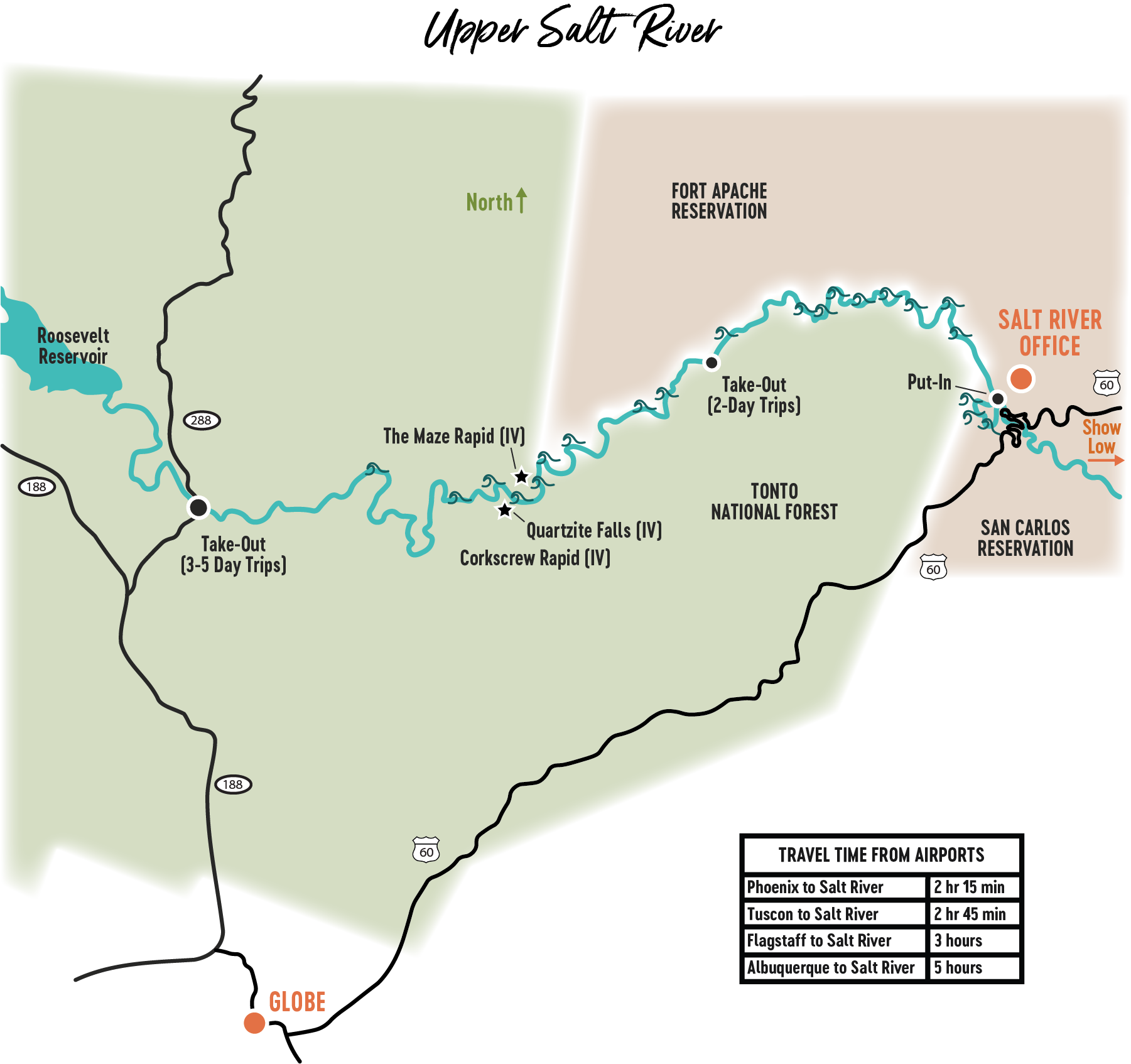
Commercial River Access, river right. For the next 15 miles, horizontal layers of the Apache Group will be visible, including the Dripping Spring Quartzite layer. |
| 1.1 |
Maytag Rapid (III) |
| 1.7 |
Grumman Rapid (III) |
| 2.3 |
Overboard Rapid (III) |
| 3.8 |
Tonto National Forest begins, river left. The middle of the river is the boundary between the National Forest and the White Mountain Apache Tribal Lands. |
| 5.5 |
Exhibition Rapid (III) |
| 8.6 |
Mescal Falls (III) |
| 10.0 |
Salt Banks, river right, are salt & mineral deposits. Visitation is prohibited, as they are considered a sacred site by the White Mountain Apache Tribe. |
| 10.2 |
Ledges Rapid (III) |
| 11.0 |
Walnut Falls, river left |
| 11.9 |
Rock Garden Rapid (III) |
| 12.0 |
Ancestral Puebloan ruins, river left at base of cliff. Visitation not permitted. |
| 13.4 |
Rat Trip Rapid (III) |
| 13.6 |
White Rock Rapid (III) |
| 16.0 |
Canyon Creek, river right, is a major tributary and begins many miles away just under the Mogollon Rim. An indigenous turquoise quarry can be visited near the mouth of the canyon, and a potential hike awaits up the canyon. |
| 16.1 |
Granite Rapid (III) |
| 21.5 |
Eye of the Needle Rapid (III) |
| 22.5 |
Black Rock Rapid (IV) |
| 26.6 |
Devil’s Pendejo Rapid (III) |
| 28.4 |
Yankee Joe Canyon, river left, named after Joseph Yankie, who operated several mines in the area in the 1870’s. |
| 29.4 |
Pinball Rapid (III) |
| 29.8 |
The Maze Rapid (IV) |
| 31.7 |
Quartzite Falls (IV), named after the large walls of steep White Ledges Quartzite framing the river leading to the rapid. |
| 31.8 |
Corkscrew Rapid (IV) |
| 35.9 |
Cherry Creek, river right, is one of the largest tributaries of the river. Named for the wild cherry trees at the mouth, this site also contains ruins of a cabin from the early 1900’s. |
| 38.4 – 39.2 |
The boundary of the Salt River Canyon Wilderness approaches the river throughout this section. |
| 41.9 |
Desert Bald Eagles have been known to nest here in the rocky spires near the river. |
| 44 – 52.3 |
The river crosses multiple faults through this section, exposing numerous rock formations. |
| 52.6 |
Highway 288 River Access take out, near the mouth of Roosevelt Reservoir! |